Singapore: A “Garden City”?
Background
Singapore’s Garden City vision was first introduced by the late prime minister Lee Kuan Yew in 1967. It was envisioned that a garden city would reap social, economic and political benefits.
With global temperatures rising as a result of climate change, cooling measures in a dense city like Singapore have become of even greater importance. Besides the social benefit of a cooler climate, cooling measures also have economic benefits such as reducing the burden on the healthcare system and reducing maintenance costs spent on repairing and replacing equipment. Singapore’s rapidly increasing ageing society of seniors are at higher risk of heat-related injuries/illnesses.
Being a Garden City also has social benefits such as improved mental health in the population. There is also a huge political incentive for Singapore to remain a Garden City. Aligned with the global fight against climate change, Singapore must show that it takes carbon emissions seriously and that maintaining our greenery is one way to do so. Furthermore, the Singapore government has committed to the SG Green Plan 2030. In order to maintain trust in the government, it is important that they achieve these objectives.
Problem Statement

2026 Target:
1) Develop over 130 HA of new parks, and enhance around 170 ha of existing parks
2030 Targets:
1) Double our annual tree planting rate between 2020 and 2030, to plant 1 million more trees across Singapore
2) Increase nature parks’ land area by over 50% from 2020 baseline
3) Every household will be within a 10-minute walk from a park
2035 Target:
1) Add 1000 HA of green spaces
The Singapore Government has always wanted to make Singapore a Garden City. The Singapore Green Plan introduced aims to develop a larger area of parks and provide more lush vegetation, and natural landscapes in Singapore. In addition, the goal is to increase nature by 50% from a baseline and ensure that more green spaces are on Singapore Island.
However, it seems that a lot of natural lands (I.e Forested Areas, GrassLand) are being demolished/taken to make way for infrastructure such as buildings (HDB, Shopping Malls, MRT etc.). Thus, all of these actions may potentially slow down the progress or negatively affect the goals of the Singapore Green Plan.
Additionally, by 2045, temperatures could rise up to 40 degrees due to climate change and urban environments release trapped heat from buildings, roads, and vehicles compounded by the rising temperature. Currently, places such as India and Eastern Europe have increased heat injuries due to the deadly summer heat waves. This trend will make Singaporeans potentially use more air conditioning when they are home, contributing to higher carbon footprints and contributions to climate change.
Project Objectives
Objective 1
The main objective of this project is to look for and make use of appropriate satellite imagery to detect and examine land cover changes over the years. Our team will use a mixture of Land Surface Temperature (LST), Classification of Forested Areas, and Classification of Urbanization to analyse the changes in those data.
With the analysis, we can determine the impacts and highlight factors in need of attention as a form of recommendation to align and ensure the Green Plan Goals are on track to be achieved by 2030.
Objective 2
The second objective is to determine the impacts of the government’s land heat mitigation measures by making use of the appropriate satellite imagery to derive the LST and suggest recommendations based on the results.
Data
Sentinel 2
Study Year 2020: S2A_MSIL1C_20200126T032011_N0208_R118_T48NUG_20200126T061348
Study Year 2022: S2B_MSIL1C_20220130T031949_N0400_R118_T48NUG_20220206T133433
Landsat 8
All available Landsat 8 satellite images from 2018 to 2022 (collated using Google Earth Engine)
Singapore Main Island Boundry
Obtained from data.gov
Master Plan 2019 Subzone Boundary (No Sea)
Obtained from data.gov
Scope of Work
- Theme selection & literature review
- Project proposal & website
- Data acquisition, extraction, processing and integration
- Perform classification on land cover
- Perform Land Surface Temperature change analysis
- Perform change detection for land cover
- Prepare poster and project webpage
- Area of interest within Singapore mainland
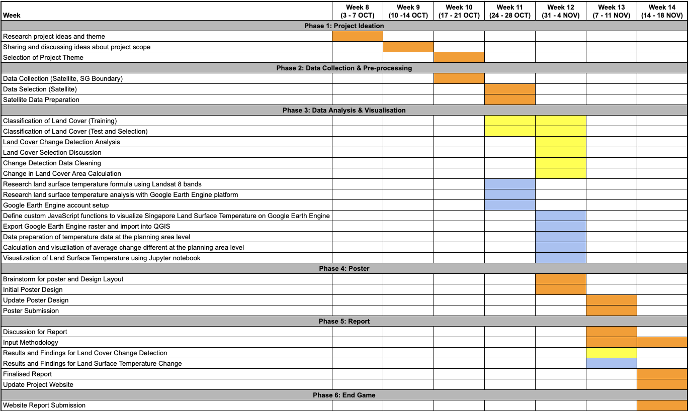
Project Schedule/Gantt Chart
Gantt Chart
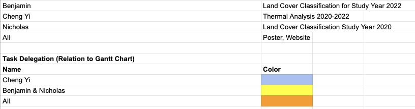
Distribution of Labour